Archive for August, 2012

Joya: resident artists / Jude and Professor Mark Macklin / 29th August

(Texto en español al final del artículo)

“Day 4, 29th August 2012

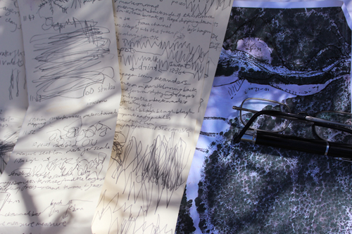
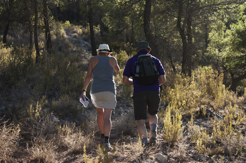
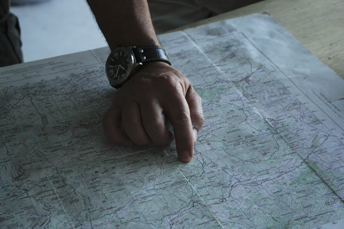
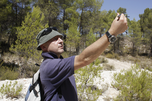
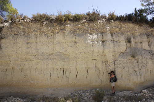
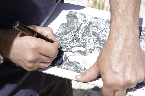
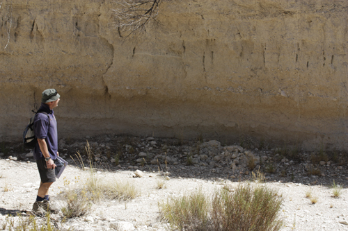
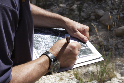
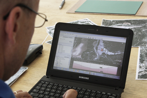
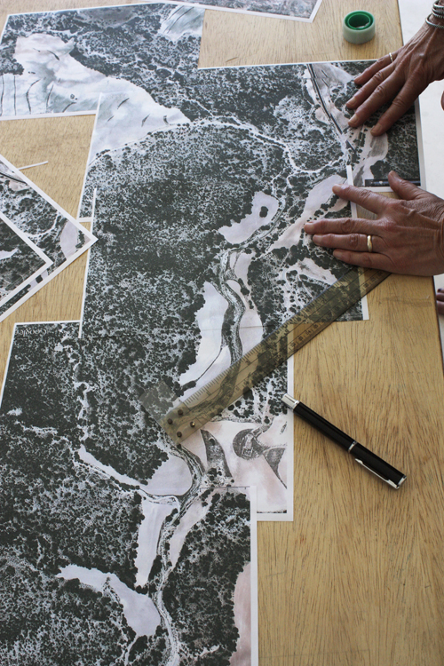
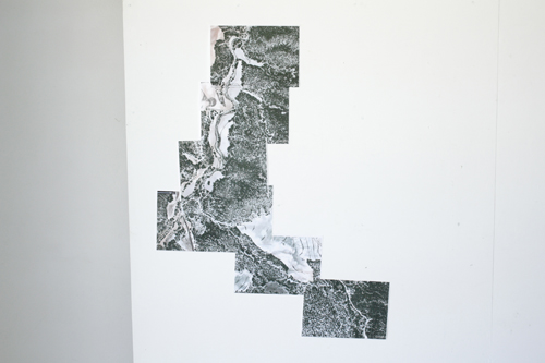
A remarkably productive day in the lab - a.k.a. the studio - transcribing field maps and notes onto final copy Google Earth base templates. Pleased with the interpretative geomorphological maps, which will underpin the prints that Jude is producing over the next 5 or 6 days. I’ve been studying river landforms and deposits for 34 years, deciphering environmental signals left in the landscape by climate change, tectonics, as well by human management and mismanagement of ecosystems. All of these themes can be explored in dryland river systems but what makes the Mediterranean region unique compared to similar climatic regions of South America, South Africa and Australia is the very long history of farming and its cumulative environmental impact. From the perspective of landscape interpretation and landscape history this presents a challenge in trying to differentiate between change caused by ‘natural’ processes such as climatic variability and those resulting from anthropogenic activity. This is not only important from an academic perspective but also for environmental management because incorrectly identifying the presumed cause of change and instability in river catchments can result in very costly and ineffective remediation and ‘restoration’ programmes. An understanding of long term (or as many environmental historians call it ‘deep time’) river behaviour and rates of change should always underpin sustainable land-use and water resource development; unfortunately, it rarely does. It was interesting for me that Jude has selected small parts - in effect samples - of my geomorphological maps highlighting the fractal nature of landscapes, particularly those produced by running water. Moreover, she has decided to juxtapose representations of those parts of the Rambla de la tia Polonia catchment that have been completely transformed by human action (primarily through the construction of agricultural terraces) with the more ‘natural’ riverscapes that are found along the Ramblas. This elegantly mirrors the long running geomorphological debate of ‘man versus nature’ as agents of change in Mediterranean catchments. Locally, many channels have been modified by the construction of stone/concrete bed-check weirs or dams designed to prevent river bed and bank erosion as well as to control and moderate sediment delivery and sedimentation in lower parts of the catchment. In the Rambla del Cajar, a major east bank tributary of the Rambla de la Tía Polonia, there is evidence that these structures have been repeatedly destroyed either by undermining by flood water or by bank collapse. They appear to be ineffective in controlling erosion in these catchments, which are primarily used for forestry. A river terrace 2-3 m above the bed of the modern channel, that grades into an extensive network of gullies many of which are now inactive, indicates that erosion rates have been much higher in the recent past (the last few centuries). So the erosion ‘horse’ has already bolted but the catchment managers don’t know it! Enter knowledge and appreciation of deep time river dynamics!!”

Prof. Mark Macklin

You can find out more on Jude and Mark Macklin’s residency here.

“Día 4, 29 de agosto de 2012

Un día extraordinariamente productivo en el estudio/laboratorio transcribiendo mapas y notas de campo sobre una copia final de las plantillas de Google Earth. Estoy satisfecho con los mapas geomorfológicos, que apuntalarán los grabados que Jude estará haciendo durante los próximos 5 ó 6 días. He estado estudiando los accidentes geográficos y depósitos durante 34 años, descifrando las señales medioambientales dejadas en el paisaje por el cambio climático, la tectónica, así como por el uso y mal uso que el ser humano ha hecho de los ecosistemas. Todas estas cuestiones pueden ser exploradas en los sistemas fluviales secos, pero lo que convierte a la zona mediterránea en única en comparación a zonas climáticas similares de Sudamérica, el sur de África y Australia es la larguísima historia agrícola y su impacto medioambiental acumulativo. Desde la perspectiva de la interpretación del paisaje y la historia del paisaje esto supone un reto a la hora de intentar diferenciar entre el cambio originado por procesos “naturales” como la variabilidad climática y aquellos que son el resultado de la actividad humana. Esto es importante no sólo desde una perspectiva académica sino también para la gestión medioambiental porque identificar incorrectamente la presunta causa del cambio e inestabilidad en las cuencas de los ríos puede dar como resultado programas de remediación y “restauración” muy costosos e inefectivos. La comprensión del comportamiento fluvial en el largo plazo (o como muchos historiadores medioambientales lo llaman, “deep time”, “tiempo profundo”) y de los ritmos de cambio siempre debería ser la base del uso sostenible del terreno y el desarrollo de los recursos hídricos, desgraciadamente, raramente lo es. Ha sido interesante para mí que Jude haya escogido pequeñas partes (o muestras) de mis mapas geomorfológicos destacando la naturaleza fractal de los paisajes, particularmente de aquellos producidos por el agua corriente. Además, ha decidido yuxtaponer representaciones de las partes de la cuenca de la Rambla de la Tía Polonia que han sido completamente transformadas por la acción humana (principalmente por la construcción de terrazas agrícolas) con los paisajes fluviales más “naturales” que se encuentran junto a las Ramblas. Esto refleja de una manera elegante el alargado debate geomorfológico de “hombre vs naturaleza” como agente de cambio en las cuencas mediterráneas. Localmente, muchos cauces han sido modificados por la construcción de diques de piedra o cemento diseñados para prevenir la erosión de la ribera así como para controlar y moderar la distribución de sedimentos y la sedimentación en las partes más bajas de la cuenca. En la Rambla del Cajar, un importante afluente oriental de la Rambla de la Tía Polonia, hay evidencias de que estas estructuras han sido repetidamente destruidas ya sea por socavación de las riadas o por el colapso de la ribera. Parecen ser inefectivos a la hora de controlar la erosión en estas cuencas, que se usan principalmente para la forestación. Una terraza fluvial a 2-3 m sobre la base del cauce actual, que deriva en una extensa red de barrancos muchos de los cuales están ahora inactivos, indica que la velocidad de la erosión fue mucho más alta en el pasado reciente (hace unos pocos siglos). De manera que la erosión ya ha comenzado, ¡pero los responsables del cuidado del cauce no lo saben! ¡Hay que conocer y comprender las dinámicas fluviales en el largo plazo!”

Prof. Mark Macklin

Share

Comments

Joya: arte + ecología/ artist in residence / Francesca Sciandra

“My proposed project is an environmental exploration using digital tools, resulting in a multimedia installation. It is based on an intuitive and data-driven analysis of natural conditions, focused on light within the landscape.

Over the period of 7 to 10 days, I will to capture a number of isolated light and environmental conditions within the Sierra de María-Los Vélez Natural Park as a feed of digital data. These may include light intensity, colors, temperature and humidity. I will use this data as a raw material for a live web-based project, and archive the information for a future installation.”

Continuing with other work in my practice, this project is concerned with our relationship to the environment, changes in personal perception, and the non-linear quality of time. The work is an extension and evolution of my piece “Weather Report,” which uses publicly available weather data from the web as the input for a series of ever-changing visual abstractions.

My art practice uses the intuitive creative process in combination with software and technology as a medium. I am interested in using traditional arts practices and technology to create dynamic forms, process environmental gestures, capture behavior, and simulate natural systems.

We cannot “see” all forces at work in the environment. Art and science have historically been the disciplines that have allowed us new understandings of our environment. This project will motivate viewers to have a closer relationship to our shared environment by seeing it with new eyes.”

Francesca Sciandra

To find out more about Francesca Sciandras project please click here.

Share

Comments

Creative Course / The Food of Art

food of art Oct 2012 (losgazquez)

The Food of Art is a creative course for those who enjoy creative activities around food such as food presentation, illustration and photography. As an eco-guest house our food is seasonal, fresh and local. Itʼs the food of a well travelled peasant, infused as it is with the colours and the flavours of India and the Mediterranean Basin.

Activities will include visiting the local markets and the jamon and embutidos emporiums to purchase the freshest and best looking products. Back at the kitchen/studio we consider the form and colour of our products. We consider how to cut and display them to maximise the creative potential of their form.

This week we came across a surfeit of Mackerel (caballa en Español) so we have been playing with ideas of what to do with it. This morning experiment is making escabeche with sherry vinegar, balsamic vinegar, bay leaves, chilli, coriander seeds, black pepper corns, sea salt, parsley stalks, brought to the boil, left to steep and poured over ‘flash fried’ mackerel and sliced onion.

Tonight we will eat the results…

foa blog

Share

Comments

Joya: resident artists / Jude and Professor Mark Macklin / 28th August

Photograph by Jude Macklin

(Texto en español al final del artículo)

‘Day 3, 28th August 2012

The provisional river terrace sequence identified in the Rambla de la Tía Polonia yesterday was confirmed and extended today with the identification of two older and higher units at c. 10-12 m and 25 m above the modern river bed. On the basis of research done by myself and others both in Spain and elsewhere in the northern Mediterranean  (see Macklin et al. 2002 Quaternary Science Reviews, 21, 1633-44) these are likely to be Late Pleistocene in age (> 11,700-130,000 years before the present). The 25 m terrace is paired (remnants are found on both sides of the valley floor) and it grades into extensive fan deposits that infill many of the smaller tributaries. This unit is poorly exposed but from the limited outcrops that are available in the upper part of the terrace, it comprises coarse gravels overlying silty clays that have a well-developed rubified (red coloured) soil. These deposits represent a major phase river aggradation in the Rambla de la Tía Polonia and very probably elsewhere in other river catchments of the Sierra de María-Los Vélez.  One conspicuous feature on the surface of the 6-8 m, 3-4 m and 2-2.5 m river terraces (that are likely to be of Holocene age – the most recent geological period of time spanning the last c. 11,700 years) are a series of old meander loops that are especially well preserved on the west side of the valley. These have a higher-sinuosity than the thalweg of the modern river, which is much straighter than these earlier river channels. This change in river channel planform is likely to be the result of long term and progressive river channel entrenchment, in combination with a period of more recent flooding (50-100 years ago? To be confirmed by dating of trees growing on 2.5-2 m terrace) that cut-off the meander loops and straightened the course of Rambla de la Tía Polonia.’

Prof. Mark Macklin

‘I saw 3 different coloured lizards today, green, yellow and orange and 1 large plump translucent white scorpion which was sheltering under a flat stone I chose to build into a homing cairn.  Once disturbed it turned its back and buried its head, nestling, leaving its tail raised in our direction.  We covered it again and walked on.

We aimed to maximise our day and progress the mapping of Rambla de la Tía Polonia (Rambla of the Polish Aunt).  It’s hot today with little breeze and my intention is to record the mapping process by making a continuous drawing.  I begin to follow Mark - mirroring his steps, the stops he makes and pick the same path as he scans the river bed, its banks and terraces.  The pace is urgent but develops a rhythm of zig and zag, stop and start, retrace and mark on the map, measure and re-measure.  My drawing evidences the toil and we stick together on the job for 3 hours.

Today we began to make a hard copy of our joint experience and joint intension.  The feeling is that we have broken through the mundane.  It’s been a good day for streaming ideas, streaming data, streaming understanding, streaming energy and streaming sweat!’

Jude Macklin

“Día 3, 28 de agosto de 2012

La terraza fluvial provisional identificada en la Rambla de la Tía Polonia ayer ha sido confirmada y extendida hoy con la identificación de dos unidades más antiguas y altas a 10-12 m y 25 m sobre el cauce del río actual. En la base de esta investigación hecha por mí mismo y otros tanto en España como en otros lugares del norte del Mediterráneo (ver Macklin et al. 2002 Quaternary Science Reviews, 21, 1633-44) es probable que éstas sean de finales del Pleistoceno (hace 11.700-130.000 años). La terraza de 25 m se encuentra a ambos lados del fondo y deriva en amplios depósitos de abanico que rellenan afluentes más pequeños. Esta unidad está pobremente expuesta, pero los pocos afloramientos que se hallan en la parte superior de la terraza contienen gravilla gruesa que se superpone a arcillas limosas compuestas de una tierra rojiza bien desarrollada.

Estos depósitos representan una fase de gran agradación en la Rambla de la Tía Polonia y muy probablemente en otras zonas geográficas fluviales  de la Sierra de María-Los Vélez. Un elemento llamativo en la superficie de las terrazas fluviales de 6-8 m, 3-4 m y de 2-2.5 m (que probablemente sean del Holoceno, el periodo geológico más reciente que abarca los últimos 11.700 años) son una serie de meandros que están especialmente bien preservados en el lado occidental del valle. Éstos tienen una sinuosidad más acentuada que la vaguada del río actual, que es mucho más recta que estos canales fluviales anteriores. Este cambio en la plataforma del cauce del río es probable que sea el resultado de una consolidación de largo plazo y progresiva del cauce del río, en combinación con un periodo de riadas más frecuentes (tal vez hace 50-100 años, lo cual se confirmará averiguando la edad en la terraza de 2-2,5 m) que cortan los meandros y enderezan el curso de la Rambla de la Tía Polonia”.

Mark Macklin


“Hoy he visto lagartos de tres colores diferentes, verde, amarillo y naranja y un grueso escorpión blanco y translúcido que estaba bajo una piedra plana que decidí transformar en un hito hogareño. Lo cubrimos de nuevo y seguimos nuestro camino.

Nuestro objetivo era maximizar nuestro día progresar en el cartografiado de la Rambla de la Tía Polonia. Hoy hace calor y corre una pequeña brisa y tengo la intención de registrar el proceso de cartografiado haciendo un dibujo continuo. Empiezo a seguir a Mark, imitando sus pasos, las paradas que hace y elijo el mismo camino a medida que escruta el cauce del río, sus riberas y terrazas. Su paso es rápido pero lleva un ritmo de zigzag, de parar y empezar, de retroceder y hacer marcas en el mapa, medir y volver a medir. Mi dibujo evidencia el duro trabajo y permanecemos unidos en el trabajo durante tres horas.

Hoy hemos empezado a hacer una copia en papel de nuestra experiencia e intención conjuntas. Tengo la sensación de que hemos salido de lo mundano. Ha sido un buen día para hacer fluir las ideas, la información, el entendimiento, la energía y ¡el sudor!”

Jude Macklin

Share

Comments

Joya: resident artists / Jude and Professor Mark Macklin / 27th August

(Texto en español al final del artículo)

‘We began the geomorphological (landform) mapping of the Rambla de la Tía Polonia today using large-scale Google Earth images as base maps. From these river terraces, palaeochannels (old and abandoned river channels) and alluvial fans (cones of sediment that accumulate at the mouths of tributary streams where they join the main river channel) can be identified and then checked on the ground by a walk-over survey. The heights of these landforms above the modern river bed (MRB) are also noted as this provides a relative age with the oldest river terraces being the highest (the Rambla de la Tía Polonia has progressively incised its valley floor over the last 10,000 years or so).  A 150 m wide and 500 m long reach of the valley floor has been mapped and this shows four major river terraces c.6 m, 4 m, 2.5 m and 1.5 m above the MRB. There may be fragments of an older terrace at 10-15 m but this will be confirmed tomorrow as the mapping is extended upstream. A preliminary inspection of the sediments that form these river terraces and their stratigraphy show that there have been considerable changes in river environment, sedimentation and erosion style. The 6 m terrace comprises clayey silts interbedded with pea-size  gravels and in the upper part of this unit there is a weakly developed soil. These are overlain by cobble-boulder size gravels that have truncated the top of the soil profile.  The 4m terrace is more poorly exposed but this period of valley floor aggradation appears to be associated with a major phase of slope erosion and sediment delivery from tributary catchments that have built up a series of alluvial fans. This has resulted in sedimentation and aggradation of the Rambla de la Tía Polonia. The filling and cutting of main river channel and floodplain is primarily controlled by the sediment dynamics of smaller tributary streams. There were no exposures in the 2.5 and 1.5 m terraces but large self-seeded pine and poplar trees on the latter unit, whose surface is covered with large cobbles and boulders, suggests that it may have been formed by a large flood perhaps 50-40 years ago. We need to know the growth rates of these trees (the largest pine trees have a circumference of c. 200 cm and the largest poplar trees have a circumference of c. 150 cm), so we can estimate when this unit stabilised.’

Prof. Mark Macklin

‘The second day in the field.  Walking, looking and talking about the dry terrain and the ‘gone’ water.  The words as descriptors are potent indicators of the place, and they circumscribe the environment into a series of compartments. Aleppo pines, kermes oak, white poplar, thistles, euphorbia, juniper, rosemary, I like the trees and plants. Watershed, gullies, barrancos, river terraces, water-bedded limestones and marls, calcium-rich shales and clays, poor percolation. I like the landforms and the geology. Cross-cutting, check weirs, stock holding, ploughing, almonds and arable, battling with nature, farming. Goats, foxes, wild boar, cats and dogs; the animals and people are equally important.  As usual I seek to see the whole and to find a common language. So I begin to draw, quickly and briefly because the page is never big enough and only more questions arise. I need to start to make prints soon.’

Jude Macklin

“Hemos comenzado hoy a cartografiar geomorfológicamente la Rambla de la Tía Polonia utilizando imágenes a gran escala de Google Earth como mapas de base. En estas terrazas fluviales se pueden identificar paleocanales (ríos antiguos y abandonados) y abanicos aluviales (conos de sedimentos que se acumulan en las bocas de afluentes donde se unen al canal principal del río) y después ser estudiados sobre el terreno. Las alturas de estos accidentes geográficos sobre el cauce del río actual también son relevantes ya que esto proporciona una edad aproximada, siendo la terraza fluvial más antigua la más alta (el fondo de la Rambla de la Tía Polonia se ha ido profundizando durante los últimos 10.000 años más o menos). Un tramo de 150 metros de ancho y 500 metros de largo ha sido cartografiado y esto muestra cuatro terrazas fluviales grandes de 6 m, 4 m, 2,5m y 1,5 m sobre el cauce del río actual. Puede que haya fragmentos de una terraza anterior a 10-15 m pero esto será confirmado mañana ya que el cartografiado se está realizando en el sentido contrario a la corriente. Una inspección preliminar de los sedimentos que forman estas terrazas fluviales y su estratigrafía muestra que ha habido cambios considerables en lo que se refiere al medio ambiente del río, la sedimentación y el tipo de erosión. En la terraza de 6 m hay limos arcillosos intercalados con gravilla del tamaño de guisantes y en la parte superior de esta unidad hay una tierra pobremente desarrollada. La gravilla está cubierta por cantos rodados que han truncado la superficie del perfil de la tierra. La terraza de 4 m está peor expuesta, pero este periodo de agradación del fondo del valle parece estar relacionado con una fase de gran erosión en la pendiente y desplazamiento de sedimentos procedentes de afluentes que han elevado una serie de abanicos aluviales. Esto ha dado como resultado sedimentación y agradación de la Rambla de la Tía Polonia. El relleno y corte del cauce principal del río y la planicie aluvial está controlada principalmente por las dinámicas de sedimentación de arroyos más pequeños. Las terrazas de 2,5 y 1,5 m no estuvieron expuestas, pero la existencia de grandes pinos y álamos en la última unidad, cuya superficie está cubierta por grandes cantos y rocas, sugiere que puede haber sido formada por grandes riadas hace 40 ó 50 años. Necesitamos saber el ritmo de crecimiento de estos árboles (los pinos más grandes tienen una circunferencia de 200 cm y el álamo más grande una circunferencia de 150 cm), de manera que podamos establecer cuándo se estableció esta unidad.”

Prof. Mark Macklin

“El segundo día en el campo. Caminando, mirando y hablando sobre el seco terreno y el agua “desaparecida”. Las palabras como descriptoras son potentes indicadoras del lugar, y circunscriben el entorno en una serie de compartimentos. Pinos de Alepo, chaparros, álamo, cardos, euphorbias, enebros, romero, me gustan los árboles y plantas. Líneas divisorias de agua, cauces, barrancos, terrazas fluviales, piedra caliza, margas, pizarras y arcillas ricas en calcio, filtración pobre. Me gustan los accidentes geográficos y la geología. Intersecciones, diques, reservas, arados, almendros y cultivos, luchando con la naturaleza, la agricultura. Cabras, zorros, jabalíes, gatos y perros; los animales y la gente son igualmente importantes. Como de costumbre, busco ver el conjunto y encontrar un lenguaje común. Así que empiezo a dibujar, rápida y brevemente porque la hoja nunca es lo suficientemente grande y sólo surge una cuestión más. Necesito hacer grabados pronto.”

Jude Macklin

Share

Comments

Joya: resident artists / Jude and Professor Mark Macklin

‘Images of environmental change in the watery realm’

_MG_9960

(Texto en español al final del artículo)

‘Water is the new oil of the 21st Century.  Environmental managers, politicians and the public are becoming increasingly aware of its ‘Janus’-like nature of with either too much or too little, with the recognition of the ambivalence of  water as both provider and destroyer. These issues are brought into sharp focus through rapid environmental change associated with globalization and anthropogenic global warming. These are very old themes that go back to the hydraulic civilizations of Egypt, Mesopotamia and the Indus but because of the disconnection between modern western societies and the watery realm they have not been explored in an art-science paradigm at a local, catchment scale.

The nature of environmental change over deep time was revealed in our very first exploration of the Rambla del Cajar with the discovery of charcoal and small fragments of bone buried beneath 6 m of colluvium (slope-derived sediments). Preserved in a ‘smile-like’, 5 cm-thick layer extending over a distance of a couple of metres, this feature represents a period of burning - perhaps the remains of a prehistoric fire (hearth) associated with a temporary riverside campsite. Its precise age is not known at present but will be dated using radiocarbon (14C) techniques. This phase of burning predates a period of major slope instability resulting from the physical breakdown by frost-action of rock and sediment, mass movement and the formation of scree-like deposits that buried this feature probably during the Late Pleistocene - the last ‘ice age’ - which ended c. 11,700 years ago. At the moment this is just a hypothesis and the 14C age will confirm or refute this idea. If the period of burning is significantly younger, this will be equally important because it will demonstrate a more recent period of large-scale slope erosion resulting in up to 5 m of Rambla aggradation (sedimentation, sediment infilling) perhaps associated with short-term climate change or human impact. This will be the first time that radiometric dating techniques have been used in this part of Andalusia to reconstruct a long-term river history.’

Prof. Mark Macklin

_MG_9968 2

_MG_9974_1

_MG_0029 2

_MG_0004 2

_MG_0007 2

_MG_0014 2

_MG_0013 2

_MG_0022 2

‘We arrived late, dark and by taxi, slept.

Our collaboration has begun, already soaking up the colours and textures of this particular place. The house and setting are stunning in the Meditterean light which bleaches colours and enhances tones.  The welcome here is astonishing and the hospitality top notch.  The simplicity of interior and exterior match in all the lines, shapes and serenity of space.  Beetles, swallows, bees, bats and …. Eagles.  Even the food on our plates matches the apparent symmetry close to sublime.

We designate the first 2 days of our 14 to recognisance and set out to walk ‘las ramblas’.

Jude Macklin

_MG_0030 2

_MG_0059 2

“Imágenes del cambio climático en el ámbito del agua”

“El agua es el nuevo petróleo del siglo XXI. Los gestores medioambientales, los políticos y el público son cada vez más conscientes de su naturaleza “Jano” (dar demasiado o demasiado poco) y su ambivalencia como proveedora y destructora. Estas cuestiones cobran especial relevancia en el contexto  del rápido cambio climático asociado con la globalización y el calentamiento global originado por el hombre. Estos temas no son nuevos y se remontan a los tiempos de las civilizaciones hidráulicas de Egipto, Mesopotamia y la cultura del valle del Indo, pero debido a la desconexión de las sociedades occidentales modernas con la cuestión del agua, estos problemas no han sido explorados en un paradigma científico-artístico en zonas geográficas concretas.

La naturaleza del cambio climático a lo largo del tiempo fue revelada en nuestra primera exploración de la Rambla del Cajar con el descubrimiento de restos de carbón y pequeños fragmentos de hueso enterrados a 6 metros de un coluvión (sedimentos en una pendiente). Preservado en una capa de 5 centímetros de grosor y unos 2 metros de extensión, estos restos de carbón son los restos de un fuego que probablemente se originó en la prehistoria en un campamento temporal situado en la orilla del río. La edad precisa de estos restos se desconoce de momento pero puede ser datada mediante técnicas de radiocarbono (carbono 14). El momento en que se originó este fuego precede a un periodo de una gran inestabilidad en las pendientes resultado del colapso provocado por la acción de las heladas en las rocas y sedimentos, desplazamientos masivos del terreno y la formación de depósitos a modo de taludes que enterraron estos restos probablemente hacia finales del Pleistoceno (la última glaciación), que finalizó hace unos 11.700 años. Por el momento esto es tan sólo una hipótesis y la datación por carbono 14 confirmará o refutará esta idea. Si el periodo en que se originó el fuego es notablemente más joven, esto será igualmente significante ya que demostrará que hubo un periodo más reciente de una gran erosión de la pendiente que dio como resultando una agradación (acumulación de sedimentos) de hasta 5 metros tal vez relacionados con una etapa de cambio climático o el impacto de la acción del hombre. Ésta será la primera vez que se habrán usado técnicas de datación radiométrica en esta zona de Andalucía para reconstruir la historia de un río”.

Prof. Mark Macklin

“Llegamos tarde, cuando ya estaba oscuro. En taxi y dormidos.

Nuestra colaboración ha comenzado. Absorbiendo ya los colores y texturas de este lugar. La casa y el emplazamiento son espectaculares en esta luz mediterránea que blanquea los colores y realza los tonos.

La bienvenida aquí fue extraordinaria y la hospitalidad inmejorable. La sencillez del interior y el exterior están en armonía con las líneas, las formas y la serenidad del espacio. Escarabajos, golondrinas, abejas, murciélagos y… águilas. Incluso la comida en nuestros platos combina con la aparente simetría cercana a lo sublime.

Hemos dedicado nuestros primeros dos días de los catorce que estaremos aquí a reconocer el entorno y caminar por las ramblas”.

Jude Macklin


Share

Comments

Creative Course / Watercolour Basics

WB-november-2012-2

Watercolour basics is a course designed to demystify the commonly held notion that watercolour is a medium which is ‘difficult’ or ‘challenging’. It is in fact a medium that possesses too many virtues to list. The important thing is to ‘take control’ of the medium and make it one’s own. To do this you must first learn a process. Once this is understood watercolour is a free and liberating medium which will allow you to express your creativity unimpeded.

What will you learn

Here at Los Gázquez we teach what we call the ‘ten ways to access creative success with your work’…

For more information look here.

Share

Comments

Creative Course / watercolour basics

WB-november-2012-2

Watercolour basics is a course designed to demystify the commonly held notion that watercolour is a medium which is ‘difficult’ or ‘challenging’. It is in fact a medium that possesses too many virtues to list. The important thing is to ‘take control’ of the medium and make it one’s own. To do this you must first learn a process. Once this is understood watercolour is a free and liberating medium which will allow you to express your creativity unimpeded.

What will you learn…

http://www.losgazquez.com/blog/?page_id=6689

For more information contact Simon [email protected]

Share

Comments

Los Gázquez / Joya: arte + ecología - client satisfaction

‘My visit seems a bit surreal now as normal life resumes. As I got on the bus to go back to Granada I really felt like I’d been away from civilization for a week and immersed myself in water colour painting, which was only made possible by the fact that I was being looked after so well by such attentive hosts and didn’t have to lift a finger!

You have created such a special atmosphere in Los Gázquez which I don’t think is easy to find. Your location is absolutely stunning, the still peace and richly coloured landscapes themselves providing such inspirational painting conditions. The accommodation and studio were spacious and airy and made the most of the special light. During my stay I became aware that the fact that the house is completely reliant on the sun and wind for its power made me feel a closeness and affinity to nature that I hadn’t experienced before.

Apart from the surroundings what also struck me was how the teaching is done in a way that is both professional and so personal . I felt that where I was in my creative journey was respected and understood and, with your expertise and experience Simon, really began to see and feel what it means to paint using water colours in what was a relatively short time. I suspect that without the right teacher I could have plateaued or  made little progress and feel extremely fortunate to have had such precious and productive learning time.

It was also so special and a privilege to hear the two resident artists, Louise and Alice, talk about their work which to me emphasised and reinforced what was being taught.

I  also loved the fact that everyone had enough private space to do whatever during the day and that we all came together in the evening. What’s vivid in my mind is the marvellous , relaxed meals and the laughter, not to mention being fabulously serenaded by 10-year-old Solomon playing an evocative guitar piece he had written himself!

Without a doubt it is an experience I am planning on repeating and I feel my painting has moved on to the extent that I don’t want to stop here but keep growing, learning more about the process of painting and about the work of specific artists that you introduced me to. In short I’ve come away from a holiday with you which has given me much more than a rest but a belief in my own creativity that I want to cultivate from now on.

GRAZIE DI CUORE e un abbraccio caloroso a tutti ! (It sounds so much better in Italian!)’

Helen

Share

Comments (1)

Joya: arte + ecología / Gareth Sambidge film

IMG_5021 2

Friend of Cortijada Los Gázquez and Joya: arte + ecología, Gareth Sambidge has been visiting and helping out with our forthcoming photography course. We went together to ‘Los Albaricoques’ the pueblo on the edge of the Cabo de Gata in Almería, to reconnoitre a good, derelict desert scene. In the past this village was used in many ‘Spaghetti Westerns’ like ‘A Few Dollars More’.
Gareth has been experimenting with a 30 to 40 year old anamorphic projector lens mounted onto a Lumix digital camera. It’s a very short film but I love the way he mixes up old and new technology to achieve visually fantastic landscape scenes…
p.s. we are hoping to persuade him to come for a residency and make more films in and around Los Gázquez next year.

El amigo de Cortijada Los Gázquez y Joya: arte + ecología Gareth Sambidge ha estado de visita y ayudándonos con nuestro próximo curso de fotografía. Fuimos juntos a Los Albaricoques, un pueblo en el límite del Cabo de Gata en Almería, para localizar un buen escenario desértico y abandonado. En el pasado este pueblo fue utilizado en muchos Spaghetti Westerns como Por “un puñado de dólares”.
Gareth ha estado experimentando con una lente anamórfica de entre 30 y 40 años de antigüedad montada en una Lumix GH2. Me gusta de manera especial la manera en que mezcla viejas y nuevas tecnologías para lograr escenas de paisajes visualmente espectaculares…
p.d. Esperamos persuadirle para que realice la residencia y haga más vídeos en y sobre Los Gázquez el próximo año.

Share

Comments (1)

« Previous entries Next Page » Next Page »